


GEOLOGICAL PROSPECTING
BAUXITES
-
Stage I — Preparatory work:
- Preparation of geological map at the scale of 1:50 000 — 1: 100 000 for all areas previously studied, as well as for sectors promising from geological and geomorphological point of view.
- In absence of topographical map – drawing up of this map using old French maps at the scale of 1: 200,000, maps of the Soviet General Staff (1: 200,000), satellite images and aerial photographs;
- Preparation of geomorphological map for more precise definition of plateau edges, on which research and evaluation of bauxite targets will be carried out;
- Development of General Program for Studying promising terrains and their bauxite potential based on maps and information available from previous works
- Preparation of Work program for each year of prospecting, including:
- General information about work area;
- Justification of the scope of work to be done;
- Methodology for each type of work;
- Timing of completion of works and their cost
- Drawing up of topographic map at the scale of 1:20 000 — 1:30 000 for each bauxite plateau
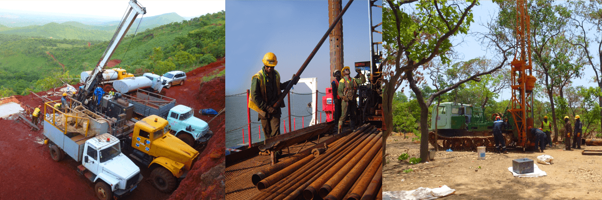
Stage II — Exploration work covering all Client Licenses (grid 600 x 600 and / or 300 x 300)
This work will be carried out in the following order:
-
Deployment of mobile camp;
- Installation of 2 to 4 benchmarks on each plateau using high precision GPS device;
-
Opening of access roads and platforms with bulldozer on each plateau;
-
Setting of drill points on approved grid with mobile GPS;
-
Auger drilling with metric sampling and brief (standardized) logging of geological profile;
-
Core drilling in order to control auger drilling and study the geological structure of bauxite layers (5-10% of the number of auger holes);
-
Transportation of samples to the main base;
-
Laboratory treatment of samples (sun drying in covered green house, quartering, crushing in jaw crushers, drying in dryer at 105 ° C, pulverization in disc pulverizers up to 150 microns), preparation of samples be sent for analysis and storage of duplicates.
-
During fieldwork, geological routes will be made on profiles and access roads opened by bulldozer for the purpose of geological and geomorphological mapping;
-
On the basis of field observations and once the results of analysis of all samples received, Geoprospects will proceed to data treatment, drawing up of maps and plans for each sector and for the whole territory, multivariate assessment of bauxite resources and drawing up of the Report on geological works with indication of promising targets and recommendations for further researches
Stage III — Preliminary prospecting (grid 150 x 150).
The work will be carried out on the best targets identified during previous exploration and approved by the Client.
This work will be done in the following order:
-
Development and coordination with the Client of Work Program;
-
Opening of access roads and platforms with bulldozer on the plateaus ;
-
Instrumental tracing of profiles and materialization of drilling points;
-
Auger drilling with metric sampling and brief (standardized) logging of geological profile;
-
Core drilling in order to control auger drilling and study the geological structure of bauxite layers (5-10% of the number of auger holes);
-
Topographic binding of drilled points with high precision GPS device or total station;
-
Transportation of samples to the main base;
-
Laboratory treatment of samples (sun drying in covered green house, quartering, crushing in jaw crushers, drying in dryer at 105 °C, pulverization in disc pulverizers up to 150 microns), preparation of samples to be sent for analysis and storage of duplicates.
-
During fieldwork, geological routes will be made on profiles and access roads opened by bulldozer for the purpose of geological and geomorphological mapping;
-
On the basis of field observations and once the results of analysis of all samples received, Geoprospects will proceed to data treatment, drawing up of maps and plans for each sector and for the whole territory, multivariate assessment of bauxite resources and drawing up a Report on geological works with indication of promising targets and recommendations for further researches.
Phase IV- Detailed prospecting (75 x 75 m):
This work will be carried out on 1-3 deposits defined as priority targets.
After drawing up of Work program, standard fieldwork usually carried out will be complemented by special researches:
- Hydrological monitoring;
- Excavation of pits to determine physico-mechanic
al properties (bulk density, expansion coefficient, coefficient of infiltration, etc.) of bauxite and related rocks (overburden and footwalls) - Studying of the mineral composition of bauxite and their technological (metallurgical) properties based on a standard laboratory digestion test.
According to the results of exploration, Geoprospects will prepare a Report containing all needed information for planning the exploitation of deposits.
IRON
Geological work on iron include:
1. Preparatory work:
- Drawing up of a predictive geological map based on previous studies indicating areas promising from geological and geomorphological point of view.
- In absence of topographical map – drawing up this map using old French maps at the scale of 1: 200,000, maps of the Soviet General Staff (1: 200,000), satellite images and aerial photographs;
- Development of General Program of exploration to be carried out in target zone and on iron deposits based on maps and information available from previous studies;
- Development of the work program for each year, including:
-
General information on the work area;
-
Justification of the scope of work to be done;
-
Methodology for each type of work;
-
Timing of completion of works and their cost;
-
Drawing up of topographic map for each sector
2. Fieldwork
-
Deployment of mobile camp;
-
Installation of basic benchmarks and determination of their coordinates in UTM WGS 84 system;
-
Tracing and implantation of geophysical profiles;
-
Geophysical survey (magnetic prospecting) on profiles or free-running on pathways using magnetometer (GEOMETRICS G-859APSX);
- Geological survey on available geophysical profiles;
-
Staking out of projected drilling points;
-
Opening of access roads and platforms with bulldozer on the plateaus;
- Diamond core drilling of inclined holes with diameter PQ, HQ and NQ;
-
Topographic instrumental binding of drilled holes in international system WGS 84 UTM;
- Logging, sampling of core with taking photos, sawing and determination of the magnetic susceptibility of rocks using kappometer KT-6;
- Preparation of samples for chemical analysis (crushing up to 2 mm, quartering, pulverization).
3. Preparation of Report on the results of geological works with several variants of resources evaluation and recommendations for further researches.
GOLD
Geological researches for gold (alluvial and native) include:
Stage I — Preparatory work:
- Drawing up of predictive geological map based on previous data showing sectors promising from geological and geomorphological point of view.
- In absence of topographical map – drawing up of this map using old French maps at the scale of 1: 200,000, maps of the Soviet General Staff (1: 200,000), satellite images and aerial photographs;
- Development of the General Program of exploration of gold areas and targets on the basis of previous data
- Preparation of the work program for each year of prospecting, including:
-
General information about work area;
-
Justification of the scope of work to be done;
-
Methodology for each type of work;
-
Timing of completion of works and their cost;
-
Drawing up of topographic map for each gold target.
Stage 2 — Identification of areas that may contain gold mineralization
Fieldwork:
-
Deployment of mobile camp;
-
Installation of basic benchmarks and determination of their coordinates in UTM WGS 84 system;
-
Tracing and implantation of exploration profiles;
-
Recognition routes with geological and geomorphological surveying;
-
Chip sampling of quartz debris and altered rocks;
-
Heavy mineral concentrate sampling in streams of first and second order;
-
Sampling through small pits in deluvio-proluvia
l deposits; -
Litho-geochemical sampling at the grid of 400 x 80 m (or 800 x 200 to 500 x 200 m), with possible further densening;
-
Mineralogical analysis of concentrates and crushed rocks;
-
On-site treatment of geochemical samples and concentrates (crushing, quartering, pulverization), preparation of samples for chemical analysis.
Office work:
- Analysis of results, preparation of report, individualizatio
n of geochemical anomalies and most promising sectors, recommendations on further works. Stage 3 — verification and delineation of areas found out during the first stage, prospecting of promising sectors
Fieldwork:
-
Digging of small pits (pipes) in alluvial deposits in order to verify the gold potential of the prospected areas;
-
Excavation of exploration trenches in areas that may contain native gold;
-
Channel sampling of trenches in identified gold zones and bodies;
-
Core drilling of inclined holes with diameter PQ on promising sectors that may contain native gold;
-
Cable percussion drilling of holes of large diameter in areas that may to contain alluvial gold or gold in the weathering crust;
-
Topographic instrumental binding of drilled holes in international system WGS 84 UTM;
-
Logging, sampling of the core and cuttings, taking pictures, sawing;
-
Mineralogical analysis of crushed rock;
- Preparation of samples for chemical analysis (crushing up to 2 mm, quartering, pulverization).
Office work:
-
Treatment of results, drawing up of report with recommendations for further work.
WATER WELL DRILLING
1. Hydrogeological studies for the purpose of construction of a large water intake
Hydrogeological exploration for the purpose of construction of large water intake include:
- Preparatory work;
- Geophysical, geological and hydrogeological field researches, exploratory hydrogeological drilling;
- Drilling and equipment of water wells;
- Preparation of report.
Preparatory work:
Preparatory works include:
- Selection and analysis of topographic maps, aerial and satellite images and hydrogeological data, interpretation of aerial photographs and satellite images in order to individualize faults and fracture zones
- Following the interpretation of topographic maps, aerial and satellite images, identification of the most promising areas and sites for geological and hydrogeological routes.
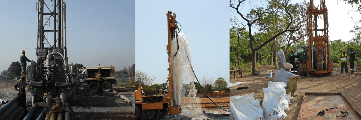
Geophysical and hydrogeological researches
Geophysical and hydrogeological researches include:
- Opening of access roads and preparation of platforms using bulldozer along plotted lines;
- Geophysical researches by vertical electrical sounding (VES) and electrical profiling (EP) on prepared profiles;
- Drilling of test holes of small diameter;
- Comparison of results of geophysical surveying and exploration drilling, drilling of hydraulic holes in promising areas;
- Air-lift development until quasi-stationary regime;
- Evaluation of well flow rate in the holes and level lowering;
- Salting resistivity measurements in boreholes with highest flow rate established according to development by air-lift; determination of water inflow intervals for installation of screens;
- Pumping during 48-72 hours in boreholes having the most productive horizons for better definition of infiltration parameters.
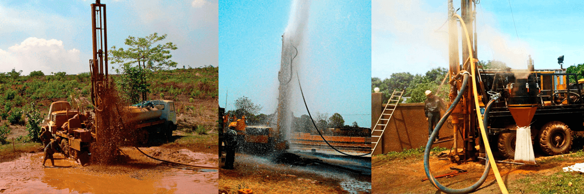
Drilling and equipment of exploitation water wells of large diameter
Drilling and equipping of boreholes will be made in the following order:
- Drilling of holes of ø 350 to 400 mm with casing of ø 320 mm in soft rocks and weathered crust;
- DHH drilling of ø 250 mm in hard rocks;
- Removing casing ø 320 mm;
- Installation of permanent PVC pipes and screens of ø 200 to 225 mm,
- Cementation of wellhead to the depth of 6-8 meters;
- Making of concrete pad 2 x 2 m at the wellhead with PVC pipe rising in the center of the pad to a height of 80 cm;
Work to be done on each hole :
- Development by air-lift during 6 hours
- Continuous pumping by 50 to 150 m3/h pump to determine infiltration parameters and flow rate of the water well,
- Collection of water samples for analysis;
- drawing up a graph of static recovery level;
- equipment of PVC pipe with cap with lock;
- Drawing up for each well a technical data sheet containing geological profile of rocks and flow rate of the hole, as well as recommendations on the depth of installation and the capacity of the industrial pump to be installed.
Drawing up a report
At the end of preparatory and fieldwork a brief report will be prepared including:
-
Brief description of geological profile and methodology of work performed;
-
Results of pumping tests and maximum estimated flow rate for each water well;
-
Drawing up a technical data sheet containing the design of water well, the description of geological profile and recommendations on the depth of installation and the capacity of industrial pump;
-
Catalogs of all water wells with coordinates obtained by GPS and parameters of each well (depth, design, flow rate, recommended depth of installation and capacity of industrial pump);
-
Topographic map at the scale of 1: 50,000 of the area showing the position of explored sectors and drilled water wells;
-
Maps for each sector showing the position of exploration boreholes and water wells at a larger scale.
2. Water well drilling for organizations and individuals
Water well drilling for organizations and individuals includes:
- Field trip, studying of hydrogeological situation, studying of the possibility of entry for the drilling rig;
- Arrival and installation of the drilling rig,
- Auger drilling in weathered crust or alluvial deposits;
- Installation of temporary casing;
- DHH Drilling ø140 to 165 mm in hard rock to the intersection of the aquifer at a depth of 60 to 110 m;
- Removing temporary casing;
- Installation of permanent PVC tubes and screens ø 125 to 140 mm;
- Airlift pumping until clear water;
- Pumping with a submersible pump for 10 hours;
- Construction of the superstructure (optional);
- Preparation of the technical data sheet for water well.